


Voting District 6021, Spokane County, Washington
About
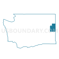
Outline

Summary
| Unique Area Identifier | 689402 |
| Name | Voting District 6021 |
| County | Spokane County |
| State | Washington |
| Area (square miles) | 0.65 |
| Land Area (square miles) | 0.65 |
| Water Area (square miles) | 0.00 |
| % of Land Area | 100.00 |
| % of Water Area | 0.00 |
| Latitude of the Internal Point | 47.58392590 |
| Longtitude of the Internal Point | -117.41756830 |
Maps


Graphs
Select a template below for downloading or customizing gragh for Voting District 6021, Spokane County, Washington


Neighbors
Neighoring Voting District (by Name) Neighboring Voting District on the Map
- Voting District 6151, Spokane County, WA
- Voting District 6154, Spokane County, WA
- Voting District 9003, Spokane County, WA
- Voting District 9005, Spokane County, WA
- Voting District 9006, Spokane County, WA
Top 10 Neighboring County Subdivision (by Population) Neighboring County Subdivision on the Map
Top 10 Neighboring Place (by Population) Neighboring Place on the Map
Top 10 Neighboring Unified School District (by Population) Neighboring Unified School District on the Map
- Spokane Public Schools, WA (221,110)
- Cheney School District, WA (33,075)
- Liberty School District, WA (4,440)